
Carte topographique Marktgemeinde Fulpmes
Carte interactive
Cliquez sur la carte pour afficher l’altitude.
À propos de cette carte
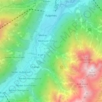
Nom : Carte topographique Marktgemeinde Fulpmes, altitude, relief.
Altitude moyenne : 1 451 m
Altitude minimum : 875 m
Altitude maximum : 2 685 m
Fulpmes est une commune du district d'Innsbruck-Land, au Tyrol (Autriche), il s'agit aussi d'une station de sports d'hiver. Son domaine skiable est connu sous le nom de Schlick 2000, domaine s'étend le long du glacier de Stubai avec un point culminant situé à 3 210 mètres d'altitude. De plus la commune dispose d'une vie nocturne et de mises en place de loisirs attrayants.
Autres cartes topographiques
Cliquez sur une carte pour visualiser sa topographie, son altitude et son relief.
Schmirn
Autriche > Tyrol > Bezirk Innsbruck-Land > Gemeinde Schmirn
Schmirn, Gemeinde Schmirn, Bezirk Innsbruck-Land, Tyrol, 6154, Autriche
Altitude moyenne : 1 890 m
Ladins
Autriche > Tyrol > Bezirk Innsbruck-Land > Schmirn
Ladins, Schmirn, Bezirk Innsbruck-Land, Tyrol, Autriche
Altitude moyenne : 1 973 m
Gemeinde Seefeld in Tirol
Autriche > Tyrol > Bezirk Innsbruck-Land
Gemeinde Seefeld in Tirol, Bezirk Innsbruck-Land, Tyrol, 6100, Autriche
Altitude moyenne : 1 303 m
Obern
Autriche > Tyrol > Bezirk Innsbruck-Land > Gemeinde Leutasch
Obern, Gemeinde Leutasch, Bezirk Innsbruck-Land, Tyrol, 6105, Autriche
Altitude moyenne : 1 330 m
Gemeinde Gnadenwald
Autriche > Tyrol > Bezirk Innsbruck-Land
Gemeinde Gnadenwald, Bezirk Innsbruck-Land, Tyrol, 6069, Autriche
Altitude moyenne : 1 277 m
Birgitz
Autriche > Tyrol > Bezirk Innsbruck-Land
Birgitz, Bezirk Innsbruck-Land, Tyrol, 6092, Autriche
Altitude moyenne : 1 208 m
Gemeinde Schmirn
Autriche > Tyrol > Bezirk Innsbruck-Land
Gemeinde Schmirn, Bezirk Innsbruck-Land, Tyrol, 6154, Autriche
Altitude moyenne : 1 908 m
Leutasch
Autriche > Tyrol > Bezirk Innsbruck-Land
Leutasch, Bezirk Innsbruck-Land, Tyrol, 6105, Autriche
Altitude moyenne : 1 461 m