
Carte topographique Birgitz
Carte interactive
Cliquez sur la carte pour afficher l’altitude.
À propos de cette carte
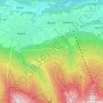
Nom : Carte topographique Birgitz, altitude, relief.
Lieu : Birgitz, Bezirk Innsbruck-Land, Tyrol, 6092, Autriche (47.19861 11.28572 47.24621 11.31694)
Altitude moyenne : 1 208 m
Altitude minimum : 665 m
Altitude maximum : 2 109 m
Autres cartes topographiques
Cliquez sur une carte pour visualiser sa topographie, son altitude et son relief.
Schmirn
Autriche > Tyrol > Bezirk Innsbruck-Land > Gemeinde Schmirn
Schmirn, Gemeinde Schmirn, Bezirk Innsbruck-Land, Tyrol, 6154, Autriche
Altitude moyenne : 1 890 m
Ladins
Autriche > Tyrol > Bezirk Innsbruck-Land > Schmirn
Ladins, Schmirn, Bezirk Innsbruck-Land, Tyrol, Autriche
Altitude moyenne : 1 973 m
Obern
Autriche > Tyrol > Bezirk Innsbruck-Land > Gemeinde Leutasch
Obern, Gemeinde Leutasch, Bezirk Innsbruck-Land, Tyrol, 6105, Autriche
Altitude moyenne : 1 330 m
Gemeinde Seefeld in Tirol
Autriche > Tyrol > Bezirk Innsbruck-Land
Gemeinde Seefeld in Tirol, Bezirk Innsbruck-Land, Tyrol, 6100, Autriche
Altitude moyenne : 1 303 m
Gemeinde Gnadenwald
Autriche > Tyrol > Bezirk Innsbruck-Land
Gemeinde Gnadenwald, Bezirk Innsbruck-Land, Tyrol, 6069, Autriche
Altitude moyenne : 1 277 m
Gemeinde Schmirn
Autriche > Tyrol > Bezirk Innsbruck-Land
Gemeinde Schmirn, Bezirk Innsbruck-Land, Tyrol, 6154, Autriche
Altitude moyenne : 1 908 m
Leutasch
Autriche > Tyrol > Bezirk Innsbruck-Land
Leutasch, Bezirk Innsbruck-Land, Tyrol, 6105, Autriche
Altitude moyenne : 1 461 m