
Faire un don
Équipez-vous pour votre prochaine aventure :
En tant que Partenaire Amazon, ce site perçoit une commission sur les achats éligibles sans surcoût pour vous.
Carte topographique Jennings County
Cliquez sur la carte pour afficher l’altitude.
Faire un don
Équipez-vous pour votre prochaine aventure :
En tant que Partenaire Amazon, ce site perçoit une commission sur les achats éligibles sans surcoût pour vous.
À propos de cette carte
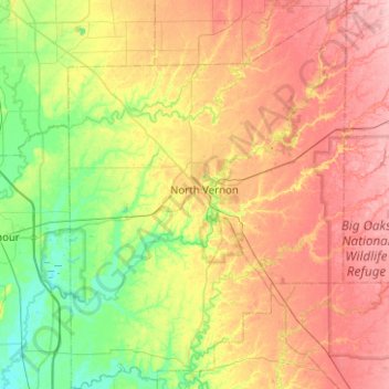
Nom : Carte topographique Jennings County, altitude, relief.
Lieu : Jennings County, Indiana, United States (38.80681 -85.79893 39.19562 -85.44005)
Altitude moyenne : 219 m
Altitude minimum : 159 m
Altitude maximum : 293 m
Faire un don
Équipez-vous pour votre prochaine aventure :
En tant que Partenaire Amazon, ce site perçoit une commission sur les achats éligibles sans surcoût pour vous.
Autres cartes topographiques
Cliquez sur une carte pour visualiser sa topographie, son altitude et son relief.
McCormick's Creek State Park
United States > Indiana > Owen County
The heart of the park is McCormick's Creek Canyon. The upper levels of the canyon are around 700 feet (210 m) above sea levels, dropping to the west fork of the White River which is near 540 feet (160 m). The McCormick's Creek waterfall is a primary attraction of the park, as Indiana has few waterfalls due to…
Altitude moyenne : 205 m
Fort Wayne
United States > Indiana > Allen County > Fort Wayne
The first settlement started in 1815. In 1819, the military garrison abandoned the fort and moved to Detroit. In 1822, a federal land office opened to sell land ceded by local Native Americans by the Treaty of St. Mary's in 1818. Platted in 1823 at the Ewing Tavern, the village became an important frontier…
Altitude moyenne : 248 m
Faire un don
Équipez-vous pour votre prochaine aventure :
En tant que Partenaire Amazon, ce site perçoit une commission sur les achats éligibles sans surcoût pour vous.