
Carte topographique Sherman Island
Carte interactive
Cliquez sur la carte pour afficher l’altitude.
À propos de cette carte
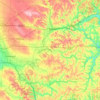
Nom : Carte topographique Sherman Island, altitude, relief.
Lieu : Sherman Island, Perry County, Ohio, 43076, USA (39.60368 -82.74460 40.24368 -82.10460)
Altitude moyenne : 294 m
Altitude minimum : 211 m
Altitude maximum : 413 m
Autres cartes topographiques
Cliquez sur une carte pour visualiser sa topographie, son altitude et son relief.
Great Seal State Park
Great Seal State Park, Metzger, Ross County, Ohio, USA
Altitude moyenne : 283 m
Bellefontaine
USA > Ohio > Bellefontaine
Bellefontaine, Lake Township, Logan County, Ohio, 43311, USA
Altitude moyenne : 384 m
Burton Lake
USA > Ohio > Burton Lake
Burton Lake, Burton Township, Geauga County, Ohio, 44021, USA
Altitude moyenne : 348 m
Chickamauga Creek
Chickamauga Creek, Gallia County, Ohio, 25515, USA
Altitude moyenne : 202 m
Detroit - Shoreway
Detroit - Shoreway, Cleveland, Cuyahoga County, Ohio, 44102, USA
Altitude moyenne : 201 m
Wales Park
Wales Park, Massillon, Stark County, Ohio, 44646, USA
Altitude moyenne : 326 m
Gorge Overlook
Gorge Overlook, Red Fox Loop Trail, Kirtland, Lake County, Ohio, 44061, USA
Altitude moyenne : 300 m
Cheviot Hills
USA > Ohio > Cheviot Hills
Cheviot Hills, Clark County, Ohio, 45505, USA
Altitude moyenne : 321 m