
Carte topographique Springdale
Carte interactive
Cliquez sur la carte pour afficher l’altitude.
À propos de cette carte
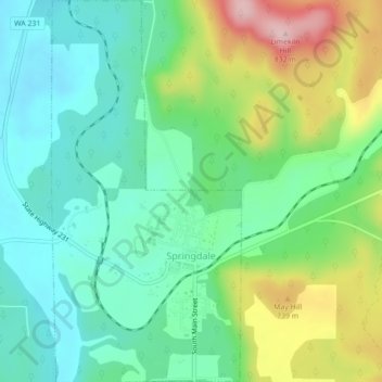
Nom : Carte topographique Springdale, altitude, relief.
Lieu : Springdale, Stevens County, Washington, United States (48.04844 -117.75785 48.07768 -117.73607)
Altitude moyenne : 656 m
Altitude minimum : 582 m
Altitude maximum : 818 m
Autres cartes topographiques
Cliquez sur une carte pour visualiser sa topographie, son altitude et son relief.
Northport
United States > Washington > Stevens County
Northport, Stevens County, Washington, 99157, United States
Altitude moyenne : 500 m
Colville
United States > Washington > Stevens County
Colville, Stevens County, Washington, United States
Altitude moyenne : 559 m
Mount Rogers
United States > Washington > Stevens County
Mount Rogers, Stevens County, Washington, United States
Altitude moyenne : 1 437 m
Calispell Peak
United States > Washington > Stevens County
Calispell Peak, Stevens County, Washington, United States
Altitude moyenne : 1 768 m
Colville
United States > Washington > Stevens County > Colville > Colville
Colville, Stevens County, Washington, United States
Altitude moyenne : 602 m