
Carte topographique Pithoragarh
Carte interactive
Cliquez sur la carte pour afficher l’altitude.
À propos de cette carte
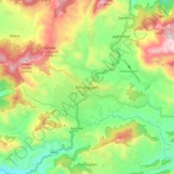
Nom : Carte topographique Pithoragarh, altitude, relief.
Altitude moyenne : 1 617 m
Altitude minimum : 1 260 m
Altitude maximum : 2 117 m
Pithoragarh is located at 29°35′N 80°13′E / 29.58°N 80.22°E / 29.58; 80.22. in the district of Pithoragarh, Uttarakhand, India. It lies in the revenue Division of Kumaon and is located 188 km northeast of Nainital, the administrative headquarters of Kumaon. It has an average elevation of 1,627 metres (5,338 feet). It is situated in the centre of the western half of the Saur Valley. The valley is spread across around 50 square kilometers. According to the Bureau of Indian Standards, on a scale ranging from I to V in order of increasing susceptibility to earthquakes, the city lies inside seismic zone V. It lies in the Moderate damage risk (B) area in Wind & Cyclone Zone and is declared a No Flood Zone.