
Carte topographique Rzeszów
Carte interactive
Cliquez sur la carte pour afficher l’altitude.
À propos de cette carte
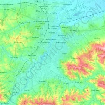
Nom : Carte topographique Rzeszów, altitude, relief.
Lieu : Rzeszów, Subcarpathian Voivodeship, Poland (49.93258 21.85868 50.08467 22.09415)
Altitude moyenne : 239 m
Altitude minimum : 190 m
Altitude maximum : 389 m
Autres cartes topographiques
Cliquez sur une carte pour visualiser sa topographie, son altitude et son relief.
Town Centre
Poland > Subcarpathian Voivodeship > Rzeszów
Town Centre, Rzeszów, Subcarpathian Voivodeship, Poland
Altitude moyenne : 207 m