
Carte topographique Wind Gap
Carte interactive
Cliquez sur la carte pour afficher l’altitude.
À propos de cette carte
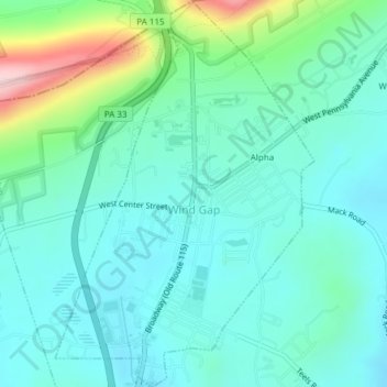
Nom : Carte topographique Wind Gap, altitude, relief.
Lieu : Wind Gap, Northampton County, Pennsylvania, United States (40.83493 -75.30521 40.86362 -75.27978)
Altitude moyenne : 255 m
Altitude minimum : 201 m
Altitude maximum : 454 m
Wind Gap is located at 40°50′47″N 75°17′30″W / 40.84639°N 75.29167°W / 40.84639; -75.29167 (40.846429, -75.291631). According to the U.S. Census Bureau, the borough has a total area of 1.4 square miles (3.6 km2), of which 0.73% is water. Wind Gap is located 21 miles (34 km) north of Allentown in the Lehigh Valley and 50 miles (80 km) southeast of Scranton, in the Wyoming Valley, or the Scranton/Wilkes-Barre metropolitan area. Wind Gap's elevation is 755 feet (230 m) above sea level.
Autres cartes topographiques
Cliquez sur une carte pour visualiser sa topographie, son altitude et son relief.
Bangor
United States > Pennsylvania > Northampton County
Bangor, Northampton County, Pennsylvania, United States
Altitude moyenne : 198 m
Allen Township
United States > Pennsylvania > Northampton County
Allen Township, Northampton County, Pennsylvania, 18067, United States
Altitude moyenne : 139 m
Brodhead
United States > Pennsylvania > Northampton County > Bethlehem Township
Brodhead, Bethlehem Township, Northampton County, Pennsylvania, 18020, United States
Altitude moyenne : 115 m
Williams Township
United States > Pennsylvania > Northampton County
Williams Township, Northampton County, Pennsylvania, United States
Altitude moyenne : 131 m
Northwood Heights
United States > Pennsylvania > Northampton County > Palmer Township > Palmer Heights
Northwood Heights, Palmer Heights, Palmer Township, Northampton County, Pennsylvania, 18045, United States
Altitude moyenne : 110 m
Mount Bethel
United States > Pennsylvania > Northampton County > Upper Mount Bethel Township
Mount Bethel, Upper Mount Bethel Township, Northampton County, Pennsylvania, 18351, United States
Altitude moyenne : 156 m
Hellertown
United States > Pennsylvania > Northampton County
Hellertown, Northampton County, Pennsylvania, United States
Altitude moyenne : 107 m
Bethlehem
United States > Pennsylvania > Northampton County > Bethlehem
Bethlehem, Northampton County, Pennsylvania, 18108, United States
Altitude moyenne : 149 m
Bushkill Township
United States > Pennsylvania > Northampton County > Bushkill Township
Bushkill Township, Northampton County, Pennsylvania, 18091, United States
Altitude moyenne : 214 m
Newport
United States > Pennsylvania > Northampton County > Newport
Newport, Northampton, Northampton County, Pennsylvania, 18037, United States
Altitude moyenne : 113 m
Nazareth
United States > Pennsylvania > Northampton County > Nazareth
Nazareth, Northampton County, Pennsylvania, United States
Altitude moyenne : 149 m
Easton
United States > Pennsylvania > Northampton County
Easton, Northampton County, Pennsylvania, United States
Altitude moyenne : 109 m