
Carte topographique Pocatello
Carte interactive
Cliquez sur la carte pour afficher l’altitude.
À propos de cette carte
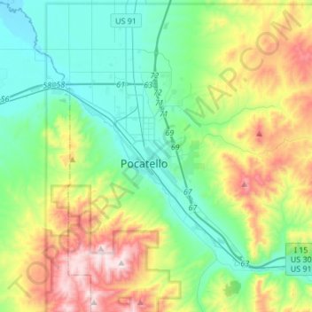
Nom : Carte topographique Pocatello, altitude, relief.
Lieu : Pocatello, Bannock County, Idaho, United States (42.80215 -112.63186 42.93149 -112.36026)
Altitude moyenne : 1 580 m
Altitude minimum : 1 328 m
Altitude maximum : 2 209 m
Pocatello is the fifth-largest city in the state, just behind Idaho Falls. In 2007, Pocatello was ranked twentieth on Forbes' list of Best Small Places for Business and Careers. Pocatello is the home of Idaho State University and the manufacturing facility of ON Semiconductor. The city is at an elevation of 4,462 feet (1.360 km) above sea level and is served by the Pocatello Regional Airport.
Autres cartes topographiques
Cliquez sur une carte pour visualiser sa topographie, son altitude et son relief.
Fort Hall
United States > Idaho > Bannock County
Fort Hall, Bannock County, Idaho, United States
Altitude moyenne : 1 377 m
Lava Hot Springs
United States > Idaho > Bannock County
Lava Hot Springs, Bannock County, Idaho, 83246, United States
Altitude moyenne : 1 611 m