
Carte topographique Chira
Carte interactive
Cliquez sur la carte pour afficher l’altitude.
À propos de cette carte
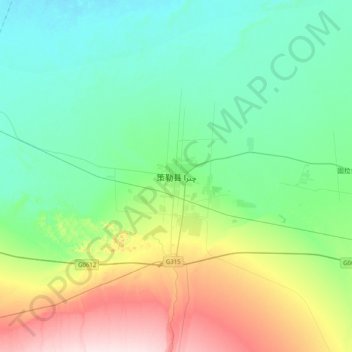
Nom : Carte topographique Chira, altitude, relief.
Lieu : Chira, Chira County, Hotan Prefecture, Xinjiang, China (36.83979 80.64153 37.15979 80.96153)
Altitude moyenne : 1 406 m
Altitude minimum : 1 313 m
Altitude maximum : 1 669 m
The southern part of Qira County is mountainous with an average elevation of 3,200 m (10,500 ft) above sea level.[1] The upper reaches of the White Jade River (Yurung Kash), which provide water for Hotan (Khotan), are found in the Kunlun Mountains[1] of southern Qira County.[23] Mountain passes in the area include Mandar Kol Dawan, Shalgon Dawan, Kuchkash Bulak Dawan, and Art Dawan.[23] One of the prominent mountains in the county is Muztag[3][24] (K5,[25] Wu-lu-ko Ho Shan,[10] Mo-shih Shan,[10] Mu-shih Shan,[26] Muztagh Jilga;[23] 慕士山,[27] 木斯山[28]) which is 7,282 m (23,891 ft) above sea level.[3] The meltwater from this mountain creates the Qira River (Cele River, Ts'e-lo Ho;[10] 策勒河[29]) which flows through Qaka into the Qira county seat.[10]