
Carte topographique East Quincy
Carte interactive
Cliquez sur la carte pour afficher l’altitude.
À propos de cette carte
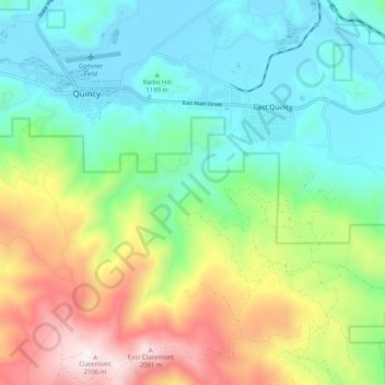
Nom : Carte topographique East Quincy, altitude, relief.
Lieu : East Quincy, Plumas County, California, United States (39.87772 -120.95454 39.95551 -120.86824)
Altitude moyenne : 1 389 m
Altitude minimum : 1 035 m
Altitude maximum : 2 132 m
East-Quincy has a Mediterranean climate (Köppen Csb) though its inland location and altitude makes it more continental and wetter than usual for this type, with very heavy snowfalls sometimes occurring in winter – the record being 133 inches (337.8 cm) in the very wet January 1916.[5][6] Although summer days are hot and only 1.4 days per winter fail to top 32 °F (0 °C), nights can be very cold and frosts occur on 179 days per year and have been recorded even in July.
Autres cartes topographiques
Cliquez sur une carte pour visualiser sa topographie, son altitude et son relief.
Quincy
United States > California > Plumas County
Quincy, Plumas County, California, 95971, United States
Altitude moyenne : 1 274 m
Ski Hill
United States > California > Plumas County
Ski Hill, Plumas County, California, 96020, United States
Altitude moyenne : 1 609 m
La Porte
United States > California > Plumas County
La Porte, Plumas County, California, United States
Altitude moyenne : 1 524 m
Indian Falls
United States > California > Plumas County
Indian Falls, Plumas County, California, United States
Altitude moyenne : 1 243 m