
Carte topographique Khamis Mushayt
Carte interactive
Cliquez sur la carte pour afficher l’altitude.
À propos de cette carte
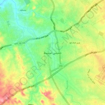
Nom : Carte topographique Khamis Mushayt, altitude, relief.
Lieu : Khamis Mushayt, 'Asir Province, 62411, Saudi Arabia (18.14000 42.57333 18.46000 42.89333)
Altitude moyenne : 2 048 m
Altitude minimum : 1 494 m
Altitude maximum : 2 372 m
Khamis Mushait has a semi-arid climate (Köppen climate classification BSk), although its high altitude of 2,066 metres or 6,780 feet makes it less extreme than most of Arabia. For instance, Riyadh is around 7.4 °C or 13.3 °F hotter on average throughout the year, despite being about 670 kilometres or 420 miles further from the equator.
Autres cartes topographiques
Cliquez sur une carte pour visualiser sa topographie, son altitude et son relief.