
Carte topographique Kent County
Carte interactive
Cliquez sur la carte pour afficher l’altitude.
À propos de cette carte
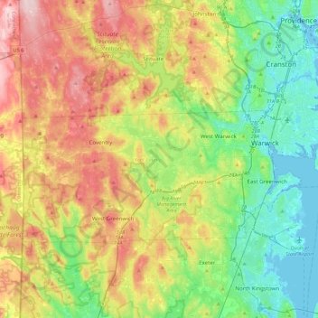
Nom : Carte topographique Kent County, altitude, relief.
Lieu : Kent County, Rhode Island, États-Unis d'Amérique (41.59675 -71.78970 41.76833 -71.35666)
Altitude moyenne : 92 m
Altitude minimum : -7 m
Altitude maximum : 241 m
Autres cartes topographiques
Cliquez sur une carte pour visualiser sa topographie, son altitude et son relief.
West Greenwich
États-Unis d'Amérique > Rhode Island > Kent County
West Greenwich, Kent County, Rhode Island, 02817, États-Unis d'Amérique
Altitude moyenne : 111 m