
Carte topographique The Municipal District of New Ross
Carte interactive
Cliquez sur la carte pour afficher l’altitude.
À propos de cette carte
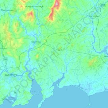
Nom : Carte topographique The Municipal District of New Ross, altitude, relief.
Altitude moyenne : 63 m
Altitude minimum : -4 m
Altitude maximum : 729 m
Autres cartes topographiques
Cliquez sur une carte pour visualiser sa topographie, son altitude et son relief.
Rosslare
Irlande > County Wexford > Rosslare
Rosslare, The Borough District of Wexford, County Wexford, Leinster, Y35 F583, Irlande
Altitude moyenne : 2 m