
Carte topographique Thornhill
Carte interactive
Cliquez sur la carte pour afficher l’altitude.
À propos de cette carte
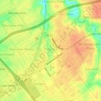
Nom : Carte topographique Thornhill, altitude, relief.
Lieu : Thornhill, Jefferson County, Kentucky, United States (38.28505 -85.62794 38.29115 -85.62304)
Altitude moyenne : 180 m
Altitude minimum : 152 m
Altitude maximum : 194 m
Autres cartes topographiques
Cliquez sur une carte pour visualiser sa topographie, son altitude et son relief.
Louisville
United States > Kentucky > Jefferson County > Louisville
Louisville, Jefferson County, Kentucky, 40202-2923, United States
Altitude moyenne : 180 m
Indian Hills Cherokee Section
United States > Kentucky > Jefferson County > Indian Hills
Indian Hills Cherokee Section, Indian Hills, Jefferson County, Kentucky, 40207, United States
Altitude moyenne : 168 m
E.P. "Tom" Sawyer State Park
United States > Kentucky > Jefferson County > Louisville > Lakeland
E.P. "Tom" Sawyer State Park, Lakeland, Louisville, Jefferson County, Kentucky, United States
Altitude moyenne : 209 m
Louisville
United States > Kentucky > Jefferson County
Louisville, Jefferson County, Kentucky, United States
Altitude moyenne : 188 m
Worthington
United States > Kentucky > Jefferson County > Louisville
Worthington, Louisville, Jefferson County, Kentucky, 40241, United States
Altitude moyenne : 208 m
Turkey Run
United States > Kentucky > Jefferson County > Louisville
Turkey Run, Louisville, Jefferson County, Kentucky, United States
Altitude moyenne : 178 m
Prospect
United States > Kentucky > Jefferson County
Prospect, Jefferson County, Kentucky, United States
Altitude moyenne : 166 m
Forest Hills
United States > Kentucky > Jefferson County > Forest Hills
Forest Hills, Jefferson County, Kentucky, United States
Altitude moyenne : 202 m
Anchorage
United States > Kentucky > Jefferson County > Anchorage
Anchorage, Jefferson County, Kentucky, United States
Altitude moyenne : 219 m
Riverside Gardens
United States > Kentucky > Jefferson County > Louisville
Riverside Gardens, Louisville, Jefferson County, Kentucky, 40216, United States
Altitude moyenne : 136 m
Coldstream
United States > Kentucky > Jefferson County
Coldstream, Jefferson County, Kentucky, United States
Altitude moyenne : 219 m
Saint Dennis
United States > Kentucky > Jefferson County > Louisville
Saint Dennis, Louisville, Jefferson County, Kentucky, 40216, United States
Altitude moyenne : 138 m