
Carte topographique Gyumri
Carte interactive
Cliquez sur la carte pour afficher l’altitude.
Gyumri
Gyumri is 126 kilometres (78 miles) north of the capital Yerevan at the central part of the Shirak plateau. It has an approximate height of 1,550 metres (5,090 feet) above sea level, the high altitude line being 1,500 metres (4,900 feet). The Akhurian River passes through the western suburbs. The Shirak plateau is surrounded with the Pambak Mountains from the east and Aragats volcanic range from the south. The city of Gyumri is 196 kilometres (122 miles) away from the Black Sea. The surrounding lands near the city are rich in tufa, basalt and clay.
À propos de cette carte
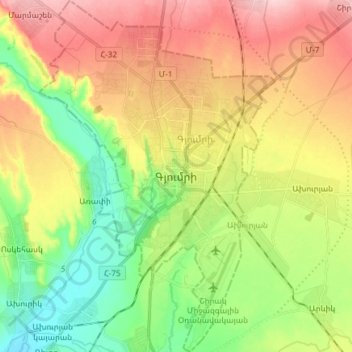
Nom : Carte topographique Gyumri, altitude, relief.
Lieu : Gyumri, Akhuryan region, Shirak Province, Armenia (40.72834 43.80913 40.83313 43.88367)
Altitude moyenne : 1 535 m
Altitude minimum : 1 459 m
Altitude maximum : 1 617 m