
Faire un don
Équipez-vous pour votre prochaine aventure :
En tant que Partenaire Amazon, ce site perçoit une commission sur les achats éligibles sans surcoût pour vous.
Carte topographique Poti
Cliquez sur la carte pour afficher l’altitude.
Faire un don
Équipez-vous pour votre prochaine aventure :
En tant que Partenaire Amazon, ce site perçoit une commission sur les achats éligibles sans surcoût pour vous.
Poti
Poti is situated 312 kilometres (194 mi) west of Georgia’s capital, Tbilisi, in a marshy delta created by the major river of western Georgia, the Rioni, at its entrance into the Black Sea. The city lies at an altitude of 2 metres (6 feet 7 inches) above sea level. A portion of Poti's environs recovered from the marshes now accommodate citrus plantation. The city is surrounded by the Kolkheti National Park. It is flanked by the small river Kaparchina to the south-east and Lake Paliastomi to the south-west. Some 5 kilometres (3 miles) to the south is the village Maltaqva, a local beach resort.
Faire un don
Équipez-vous pour votre prochaine aventure :
En tant que Partenaire Amazon, ce site perçoit une commission sur les achats éligibles sans surcoût pour vous.
À propos de cette carte
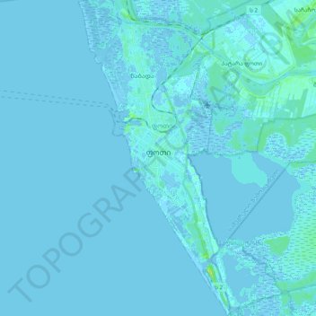
Nom : Carte topographique Poti, altitude, relief.
Lieu : Poti, Samegrelo-Upper Svaneti, 4400, Georgia (42.06858 41.62686 42.20899 41.71988)
Altitude moyenne : 1 m
Altitude minimum : -4 m
Altitude maximum : 12 m
Faire un don
Équipez-vous pour votre prochaine aventure :
En tant que Partenaire Amazon, ce site perçoit une commission sur les achats éligibles sans surcoût pour vous.
Autres cartes topographiques
Cliquez sur une carte pour visualiser sa topographie, son altitude et son relief.
Jvari
Georgia > Samegrelo-Upper Svaneti > Tsalenjikha Municipality
Jvari (Georgian: ჯვარი) is a town in the northwestern Georgian province of Samegrelo-Zemo Svaneti. The town is situated at an altitude of 280 metres near the Magana River where it flows into the Enguri River; The town is divided in two with "Jvari" lying on the Zugdidi-Mestia highway, and Jvarzeni…
Altitude moyenne : 450 m
Faire un don
Équipez-vous pour votre prochaine aventure :
En tant que Partenaire Amazon, ce site perçoit une commission sur les achats éligibles sans surcoût pour vous.
Senaki
Georgia > Samegrelo-Upper Svaneti > Senaki Municipality
Senaki (Georgian: სენაკი, senak'i; Mingrelian: სანაკი, sanak'i) is a city in Samegrelo-Zemo Svaneti region, western Georgia. It is located at around 42°16′8″N 42°4′45″E / 42.26889°N 42.07917°E / 42.26889; 42.07917 between the rivers Tekhura/i and Tsivi, at an…
Altitude moyenne : 80 m
Nokalakevi (Tsikhegoji)
Georgia > Samegrelo-Upper Svaneti > Senaki Municipality > Gakhomela
Altitude moyenne : 158 m
Faire un don
Équipez-vous pour votre prochaine aventure :
En tant que Partenaire Amazon, ce site perçoit une commission sur les achats éligibles sans surcoût pour vous.
Very steep, dangerous route
Georgia > Samegrelo-Upper Svaneti > Mestia Municipality
Altitude moyenne : 1 875 m
Faire un don
Équipez-vous pour votre prochaine aventure :
En tant que Partenaire Amazon, ce site perçoit une commission sur les achats éligibles sans surcoût pour vous.
Mestia
Georgia > Samegrelo-Upper Svaneti > Mestia Municipality
Mestia (Georgian: მესტია IPA: [mestʼia]) is a highland townlet (daba) in northwest Georgia, at an elevation of 1,500 metres (4,921 feet) in the Caucasus Mountains.
Altitude moyenne : 1 761 m
Faire un don
Équipez-vous pour votre prochaine aventure :
En tant que Partenaire Amazon, ce site perçoit une commission sur les achats éligibles sans surcoût pour vous.
Faire un don
Équipez-vous pour votre prochaine aventure :
En tant que Partenaire Amazon, ce site perçoit une commission sur les achats éligibles sans surcoût pour vous.
Gachedili
Georgia > Samegrelo-Upper Svaneti > Martvili Municipality
Gachedili (Georgian: გაჭედილი; Mingrelian: გოჭკადილი) is a village located in the Martvili Municipality of the Samegrelo-Zemo Svaneti region in Georgia. Gachedili is situated on the right bank of the Abasha river. At an altitude of 240 meters, it is 8 kilometers to Martvili…
Altitude moyenne : 354 m
Mestia
Georgia > Samegrelo-Upper Svaneti > Mestia Municipality
Mestia (Georgian: მესტია IPA: [mestʼia]) is a highland townlet (daba) in northwest Georgia, at an elevation of 1,500 metres (4,921 feet) in the Caucasus Mountains.
Altitude moyenne : 1 761 m
Faire un don
Équipez-vous pour votre prochaine aventure :
En tant que Partenaire Amazon, ce site perçoit une commission sur les achats éligibles sans surcoût pour vous.
Nokalakevi (Tsikhegoji)
Georgia > Samegrelo-Upper Svaneti > Senaki Municipality > Gakhomela
Altitude moyenne : 158 m
Faire un don
Équipez-vous pour votre prochaine aventure :
En tant que Partenaire Amazon, ce site perçoit une commission sur les achats éligibles sans surcoût pour vous.
Faire un don
Équipez-vous pour votre prochaine aventure :
En tant que Partenaire Amazon, ce site perçoit une commission sur les achats éligibles sans surcoût pour vous.
Mestia
Georgia > Samegrelo-Upper Svaneti > Mestia Municipality
Mestia (Georgian: მესტია IPA: [mestʼia]) is a highland townlet (daba) in northwest Georgia, at an elevation of 1,500 metres (4,921 feet) in the Caucasus Mountains.
Altitude moyenne : 1 761 m
Senaki
Georgia > Samegrelo-Upper Svaneti > Senaki Municipality
Senaki (Georgian: სენაკი; Mingrelian: სანაკი) is a town in Samegrelo-Zemo Svaneti region, western Georgia. It is located at around 42°16′8″N 42°4′45″E / 42.26889°N 42.07917°E / 42.26889; 42.07917Coordinates: 42°16′8″N 42°4′45″E / 42.26889°N…
Altitude moyenne : 84 m
Zugdidi
Georgia > Samegrelo-Upper Svaneti > Zugdidi
Zugdidi (Georgian: ზუგდიდი; Mingrelian: ზუგდიდი or ზუგიდი) is a city in the western Georgian historical province of Samegrelo (Mingrelia). It is situated in the north-west of that province. The city is located 318 kilometres west of Tbilisi, 30 km from the Black Sea…
Altitude moyenne : 112 m