
Carte topographique Unokoti
Carte interactive
Cliquez sur la carte pour afficher l’altitude.
À propos de cette carte
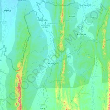
Nom : Carte topographique Unokoti, altitude, relief.
Lieu : Unokoti, Tripura, India (23.99051 91.90787 24.39156 92.20439)
Altitude moyenne : 70 m
Altitude minimum : 17 m
Altitude maximum : 430 m
The topographic features seem to have influenced the climatic condition of the Unakoti district, where the plains are hotter and humid in comparison to the hills, which have a salubrious climate. The four main seasons here are
Autres cartes topographiques
Cliquez sur une carte pour visualiser sa topographie, son altitude et son relief.
Haora River
Haora River, Agartala, West Tripura, Tripura, 799001, India
Altitude moyenne : 18 m
Kailashahar
India > Tripura > Gournagar > Kailashahar
Kailashahar, Gournagar, Unokoti, Tripura, 799277, India
Altitude moyenne : 33 m
South Tripura
India > Tripura > South Tripura
South Tripura, Gomati, Tripura, India
Altitude moyenne : 75 m