
Carte topographique Minot
Carte interactive
Cliquez sur la carte pour afficher l’altitude.
À propos de cette carte
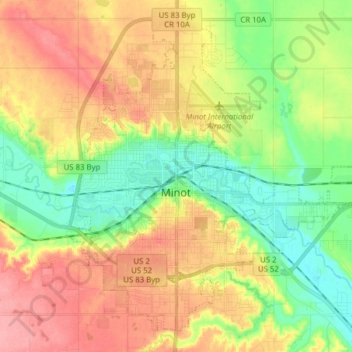
Nom : Carte topographique Minot, altitude, relief.
Lieu : Minot, Ward County, North Dakota, United States (48.19164 -101.34295 48.28304 -101.18767)
Altitude moyenne : 510 m
Altitude minimum : 467 m
Altitude maximum : 558 m
The elevation of the river at the city center is 1,540 feet (470 m) above sea level. The valley sits 160 feet (49 m) below the surrounding plains; the elevation at the Minot International Airport on North Hill is 1,716 feet (523 m). The city has several small horseshoe-shaped oxbow lakes within its limits near the river, created by the Mouse's meandering course.
Autres cartes topographiques
Cliquez sur une carte pour visualiser sa topographie, son altitude et son relief.
Kenmare
United States > North Dakota > Ward County
Kenmare, Ward County, North Dakota, United States
Altitude moyenne : 577 m
Burlington
United States > North Dakota > Ward County
Burlington, Ward County, North Dakota, United States
Altitude moyenne : 500 m
Sawyer
United States > North Dakota > Ward County
Sawyer, Ward County, North Dakota, United States
Altitude moyenne : 488 m
Berthold
United States > North Dakota > Ward County > Berthold
Berthold, Ward County, North Dakota, United States
Altitude moyenne : 634 m