
Carte topographique Neubrandenburg
Carte interactive
Cliquez sur la carte pour afficher l’altitude.
À propos de cette carte
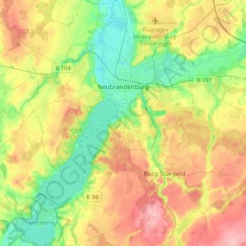
Nom : Carte topographique Neubrandenburg, altitude, relief.
Altitude moyenne : 58 m
Altitude minimum : 7 m
Altitude maximum : 127 m
Autres cartes topographiques
Cliquez sur une carte pour visualiser sa topographie, son altitude et son relief.
Ave
Germany > Mecklenburg-Vorpommern > Mecklenburgische Seenplatte > Penzlin
Ave, Penzlin, Penzliner Land, Mecklenburgische Seenplatte, Mecklenburg-Vorpommern, 17217, Germany
Altitude moyenne : 59 m
Friedland
Germany > Mecklenburg-Vorpommern > Mecklenburgische Seenplatte
Friedland, Mecklenburgische Seenplatte, Mecklenburg-Vorpommern, Germany
Altitude moyenne : 37 m
Wildberg
Germany > Mecklenburg-Vorpommern > Mecklenburgische Seenplatte > Wildberg
Wildberg, Treptower Tollensewinkel, Mecklenburgische Seenplatte, Mecklenburg-Vorpommern, Germany
Altitude moyenne : 59 m
Bartow
Germany > Mecklenburg-Vorpommern > Mecklenburgische Seenplatte > Bartow
Bartow, Treptower Tollensewinkel, Mecklenburgische Seenplatte, Mecklenburg-Vorpommern, Germany
Altitude moyenne : 20 m
Kieve
Germany > Mecklenburg-Vorpommern > Mecklenburgische Seenplatte > Kieve
Kieve, Röbel-Müritz, Mecklenburgische Seenplatte, Mecklenburg-Vorpommern, Germany
Altitude moyenne : 73 m
Weisdin
Germany > Mecklenburg-Vorpommern > Mecklenburgische Seenplatte > Blumenholz > Weisdin
Weisdin, Blumenholz, Neustrelitz-Land, Mecklenburgische Seenplatte, Mecklenburg-Vorpommern, 17237, Germany
Altitude moyenne : 77 m