
Carte topographique Wörschweiler
Carte interactive
Cliquez sur la carte pour afficher l’altitude.
À propos de cette carte
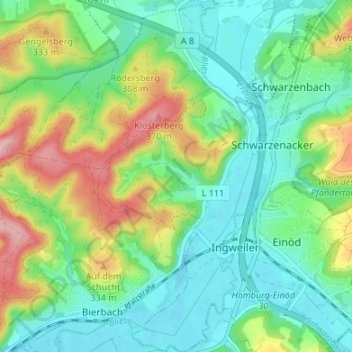
Nom : Carte topographique Wörschweiler, altitude, relief.
Lieu : Wörschweiler, Homburg, Saarpfalz-Kreis, Saarland, Deutschland (49.25809 7.28056 49.30179 7.31329)
Altitude moyenne : 269 m
Altitude minimum : 215 m
Altitude maximum : 385 m
Wörschweiler liegt ca. 4 km südwestlich von Homburg im Tal der Blies auf einer Höhe von 227 m ü. NHN. Nachbarorte sind Bierbach, Schwarzenacker, Beeden und Limbach. Der Ort wird von der Autobahn 8 tangiert.
Autres cartes topographiques
Cliquez sur une carte pour visualiser sa topographie, son altitude et son relief.
Erbach
Deutschland > Saarland > Homburg
Erbach, Homburg, Saarpfalz-Kreis, Saarland, Deutschland
Altitude moyenne : 254 m
Eichelscheid
Deutschland > Saarland > Homburg
Eichelscheid, Bruchhof-Sanddorf, Homburg, Saarpfalz-Kreis, Saarland, Deutschland
Altitude moyenne : 258 m
Websweiler
Deutschland > Saarland > Homburg
Websweiler, Jägersburg, Homburg, Saarpfalz-Kreis, Saarland, Deutschland
Altitude moyenne : 349 m