
Faire un don
Équipez-vous pour votre prochaine aventure :
En tant que Partenaire Amazon, ce site perçoit une commission sur les achats éligibles sans surcoût pour vous.
Carte topographique Cache Creek
Cliquez sur la carte pour afficher l’altitude.
Faire un don
Équipez-vous pour votre prochaine aventure :
En tant que Partenaire Amazon, ce site perçoit une commission sur les achats éligibles sans surcoût pour vous.
À propos de cette carte
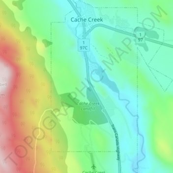
Nom : Carte topographique Cache Creek, altitude, relief.
Altitude moyenne : 658 m
Altitude minimum : 418 m
Altitude maximum : 1 214 m
Faire un don
Équipez-vous pour votre prochaine aventure :
En tant que Partenaire Amazon, ce site perçoit une commission sur les achats éligibles sans surcoût pour vous.
Autres cartes topographiques
Cliquez sur une carte pour visualiser sa topographie, son altitude et son relief.
Kingsvale
Canada > British Columbia > Thompson-Nicola Regional District > Area N (Beautiful Nicola Valley - South)
Altitude moyenne : 928 m
Dragon Cone
Canada > British Columbia > Thompson-Nicola Regional District > Area A (Wells Gray Country)
Altitude moyenne : 1 703 m
Spences Bridge
Canada > British Columbia > Thompson-Nicola Regional District > Area I (Blue Sky Country)
Spences Bridge's location is mountainous, with higher elevations part of the Interior Plateau. The east side of the Fraser here is part of the Clear Range, a mountainous southwards extension of the Fraser Plateau located in the angle of the Thompson and Fraser Rivers. Arthur Seat lies in that range on the west…
Altitude moyenne : 495 m
Black Canyon
Canada > British Columbia > Thompson-Nicola Regional District > Area I (Blue Sky Country)
Altitude moyenne : 386 m
Faire un don
Équipez-vous pour votre prochaine aventure :
En tant que Partenaire Amazon, ce site perçoit une commission sur les achats éligibles sans surcoût pour vous.
Gisborne Lake
Canada > British Columbia > Thompson-Nicola Regional District > Area J (Copper Desert Country)
Altitude moyenne : 1 321 m
Merritt
Canada > British Columbia > Thompson-Nicola Regional District > Merritt
Altitude moyenne : 1 099 m
Hemp Creek
Canada > British Columbia > Thompson-Nicola Regional District > Area A (Wells Gray Country)
Altitude moyenne : 988 m
Kamloops
Canada > British Columbia > Thompson-Nicola Regional District > Kamloops
Altitude moyenne : 875 m
Faire un don
Équipez-vous pour votre prochaine aventure :
En tant que Partenaire Amazon, ce site perçoit une commission sur les achats éligibles sans surcoût pour vous.
Fraser Plateau
Canada > British Columbia > Thompson-Nicola Regional District > Area J (Copper Desert Country)
Altitude moyenne : 1 800 m
Williams Creek
Canada > British Columbia > Thompson-Nicola Regional District > Area J (Copper Desert Country)
Altitude moyenne : 1 100 m
Dagger Lake
Canada > British Columbia > Thompson-Nicola Regional District > Area O (Lower North Thompson)
Altitude moyenne : 1 484 m
Mount St. Anne
Canada > British Columbia > Thompson-Nicola Regional District > Area B (Thompson Headwaters)
Altitude moyenne : 1 901 m
Faire un don
Équipez-vous pour votre prochaine aventure :
En tant que Partenaire Amazon, ce site perçoit une commission sur les achats éligibles sans surcoût pour vous.