
Carte topographique Cagayancillo
Carte interactive
Cliquez sur la carte pour afficher l’altitude.
À propos de cette carte
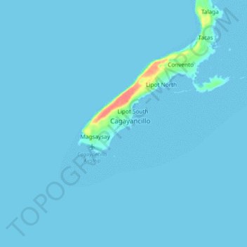
Nom : Carte topographique Cagayancillo, altitude, relief.
Lieu : Cagayancillo, Palawan, Mimaropa, 5321, Philippines (9.53691 121.15715 9.61691 121.23715)
Altitude moyenne : 2 m
Altitude minimum : 0 m
Altitude maximum : 61 m
There are neither mountain ranges nor forested areas in the municipality. A hilly portion in the north-eastern part of the main island has a slope of 3-82%. The other areas are flat with the highest elevation around 2 to 3 meters. The majority of the island has a sandy loam soil not enough to support a forest.
Autres cartes topographiques
Cliquez sur une carte pour visualiser sa topographie, son altitude et son relief.
Cagayancillo
Philippines > Palawan > Cagayancillo
Cagayancillo, Palawan, Mimaropa, 5321, Philippines
Altitude moyenne : 0 m