
Carte topographique St. John's
Carte interactive
Cliquez sur la carte pour afficher l’altitude.
À propos de cette carte
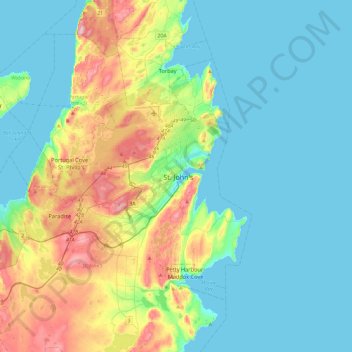
Nom : Carte topographique St. John's, altitude, relief.
Altitude moyenne : 66 m
Altitude minimum : -1 m
Altitude maximum : 272 m
Autres cartes topographiques
Cliquez sur une carte pour visualiser sa topographie, son altitude et son relief.
Airport Road
Canada > Newfoundland and Labrador > St. John's
Airport Road, St. John's, Newfoundland, Newfoundland and Labrador, A1A 4Y3, Canada
Altitude moyenne : 145 m
Blackhead
Canada > Newfoundland and Labrador > St. John's > Blackhead
Blackhead, St. John's, Newfoundland and Labrador, Canada
Altitude moyenne : 48 m