
Carte topographique José Falcón
Carte interactive
Cliquez sur la carte pour afficher l’altitude.
À propos de cette carte
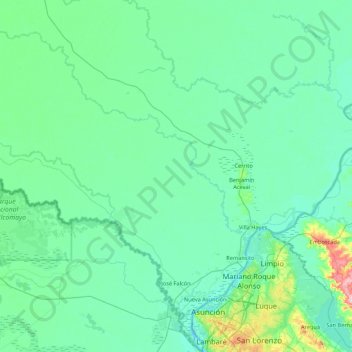
Nom : Carte topographique José Falcón, altitude, relief.
Lieu : José Falcón, Presidente Hayes, Región Occidental, Paraguay (-25.27014 -58.50207 -24.68955 -57.64361)
Altitude moyenne : 74 m
Altitude minimum : 49 m
Altitude maximum : 272 m
Located in the Western region of Paraguay, in the area of Paraguayan Chaco. Its physical appearance is part of the characteristics of the Chaco soil: lowland with abundant vegetation of palm trees. It is a coastal city located at the junction between the Pilcomayo and Paraguay rivers. This district is located in a lowland area with clay soil. With no meaningful elevations. The geography in general at this part of the department is characterized by being swampy, with palm trees and grasses. It is a region that is highly prone to flooding in the rainy seasons of the year.
Autres cartes topographiques
Cliquez sur une carte pour visualiser sa topographie, son altitude et son relief.
Colonia 96
Colonia 96, Presidente Hayes, Región Occidental, Paraguay
Altitude moyenne : 79 m
San Francisco
Paraguay > Presidente Hayes > San Francisco
San Francisco, Presidente Hayes, Región Occidental, 9800, Paraguay
Altitude moyenne : 73 m