
Carte topographique Abraham Lake
Carte interactive
Cliquez sur la carte pour afficher l’altitude.
À propos de cette carte
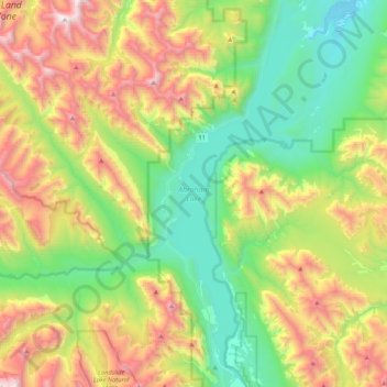
Nom : Carte topographique Abraham Lake, altitude, relief.
Lieu : Abraham Lake, Census Division No. 9, Alberta, Canada (52.07360 -116.48898 52.33277 -116.32587)
Altitude moyenne : 1 886 m
Altitude minimum : 1 222 m
Altitude maximum : 3 095 m
The Government of Alberta sponsored a contest to name the lake in February 1972, during the final stages of construction of the Bighorn Dam. Students across the province were asked to submit names taking into consideration "historical significance, prominent persons, geography and topography, and the value of the lake." It was eventually named after Silas Abraham (c. 1870–1964), of the Stoney Nakoda First Nation and originally from Morley, Alberta. He was a farmer and hunter who lived in the Kootenay Plains and later on the Big Horn 144A reserve.
Autres cartes topographiques
Cliquez sur une carte pour visualiser sa topographie, son altitude et son relief.
Moutain Vew Park
Canada > Alberta > Census Division No. 9 > Rocky Mountain House
Moutain Vew Park, Rocky Mountain House, Census Division No. 9, Alberta, Canada
Altitude moyenne : 978 m