
Carte topographique Hanmer Springs
Carte interactive
Cliquez sur la carte pour afficher l’altitude.
À propos de cette carte
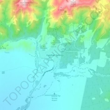
Nom : Carte topographique Hanmer Springs, altitude, relief.
Altitude moyenne : 397 m
Altitude minimum : 324 m
Altitude maximum : 677 m
The Jacks Pass – Clarence River – Jollies Pass Loop is a 25 kilometer loop which is not technically challenging however it takes between two to four hours to complete. It can be ridden in either direction: West over Jacks Pass (869m) or East over Jollies Pass (850m). As the entire ride is at high elevation (700 meters above sea level) it is subject to extreme and sudden changes in the weather which have caught riders out who were not prepared.
Autres cartes topographiques
Cliquez sur une carte pour visualiser sa topographie, son altitude et son relief.
Philosophers Knob
New Zealand > Canterbury > Hurunui District
Philosophers Knob, Hurunui District, Canterbury, New Zealand
Altitude moyenne : 1 518 m
Motunau Beach
New Zealand > Canterbury > Hurunui District > Motunau Beach
Motunau Beach, Hurunui District, Canterbury, New Zealand
Altitude moyenne : 27 m