
Carte topographique Kokol
Carte interactive
Cliquez sur la carte pour afficher l’altitude.
À propos de cette carte
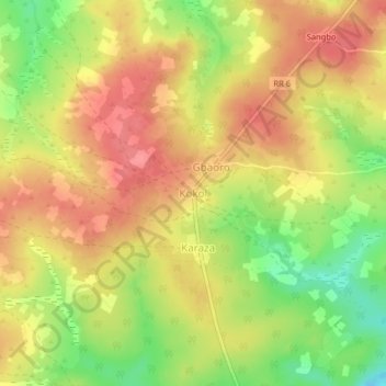
Nom : Carte topographique Kokol, altitude, relief.
Lieu : Kokol, Ouham-Pendé, Central African Republic (6.39647 16.32917 6.43647 16.36917)
Altitude moyenne : 673 m
Altitude minimum : 627 m
Altitude maximum : 703 m
Autres cartes topographiques
Cliquez sur une carte pour visualiser sa topographie, son altitude et son relief.
Sah
Central African Republic > Ouham-Pendé
Sah, Ouham-Pendé, Central African Republic
Altitude moyenne : 1 226 m
Bang
Central African Republic > Ouham-Pendé
Bang, Ouham-Pendé, Central African Republic
Altitude moyenne : 607 m
De Gaulle
Central African Republic > Ouham-Pendé > De Gaulle
De Gaulle, Ouham-Pendé, Central African Republic
Altitude moyenne : 1 155 m
Bokaya
Central African Republic > Ouham-Pendé > Bokaya
Bokaya, Ouham-Pendé, Central African Republic
Altitude moyenne : 899 m
Bocaranga
Central African Republic > Ouham-Pendé > Bocaranga
Bocaranga, Ouham-Pendé, Central African Republic
Altitude moyenne : 1 026 m