
Faire un don
Équipez-vous pour votre prochaine aventure :
En tant que Partenaire Amazon, ce site perçoit une commission sur les achats éligibles sans surcoût pour vous.
Carte topographique Pribylina
Cliquez sur la carte pour afficher l’altitude.
Faire un don
Équipez-vous pour votre prochaine aventure :
En tant que Partenaire Amazon, ce site perçoit une commission sur les achats éligibles sans surcoût pour vous.
Pribylina
The municipality lies at an altitude of 765 metres and covers an area of 86.124 km2. It has a population of about 1,362 people. There is an open-air museum of Liptov near the village, opened in 1991. There is an Autocamp near the entrance of the Račková valley. The river Belá flowing around the village is suitable for rafting.
Faire un don
Équipez-vous pour votre prochaine aventure :
En tant que Partenaire Amazon, ce site perçoit une commission sur les achats éligibles sans surcoût pour vous.
À propos de cette carte
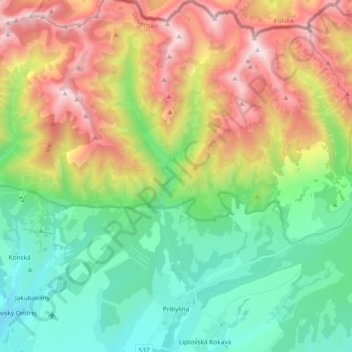
Nom : Carte topographique Pribylina, altitude, relief.
Altitude moyenne : 1 237 m
Altitude minimum : 671 m
Altitude maximum : 2 224 m
Faire un don
Équipez-vous pour votre prochaine aventure :
En tant que Partenaire Amazon, ce site perçoit une commission sur les achats éligibles sans surcoût pour vous.
Autres cartes topographiques
Cliquez sur une carte pour visualiser sa topographie, son altitude et son relief.
Ďumbier
Slovakia > Region of Žilina > District of Liptovský Mikuláš > Liptovský Ján
Altitude moyenne : 1 669 m
Tatralandia
Slovakia > Region of Žilina > District of Liptovský Mikuláš > Liptovský Mikuláš
Altitude moyenne : 590 m
Volovec / Wołowiec
Slovakia > Region of Žilina > District of Liptovský Mikuláš
There are two marked hiking trails which lead to the summit of Volovec, red and blue. A third, green one, connects with the blue one at the saddle beneath the mountain. All routes pose no technical difficulty and when taking into account the relatively large distance and altitude difference involved, the…
Altitude moyenne : 1 678 m