
Faire un don
Équipez-vous pour votre prochaine aventure :
En tant que Partenaire Amazon, ce site perçoit une commission sur les achats éligibles sans surcoût pour vous.
Carte topographique New Romney
Cliquez sur la carte pour afficher l’altitude.
Faire un don
Équipez-vous pour votre prochaine aventure :
En tant que Partenaire Amazon, ce site perçoit une commission sur les achats éligibles sans surcoût pour vous.
À propos de cette carte
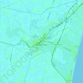
Nom : Carte topographique New Romney, altitude, relief.
Altitude moyenne : 2 m
Altitude minimum : -1 m
Altitude maximum : 8 m
Faire un don
Équipez-vous pour votre prochaine aventure :
En tant que Partenaire Amazon, ce site perçoit une commission sur les achats éligibles sans surcoût pour vous.
Autres cartes topographiques
Cliquez sur une carte pour visualiser sa topographie, son altitude et son relief.
Park Gate
United Kingdom > England > Kent > Folkestone and Hythe District > Elham
Altitude moyenne : 130 m
Faire un don
Équipez-vous pour votre prochaine aventure :
En tant que Partenaire Amazon, ce site perçoit une commission sur les achats éligibles sans surcoût pour vous.
Greatstone beach
United Kingdom > England > Kent > Folkestone and Hythe District > New Romney > Littlestone on Sea
Altitude moyenne : 2 m
The Warren
United Kingdom > England > Kent > Folkestone and Hythe District > Folkestone
Altitude moyenne : 46 m
Greatstone on Sea
United Kingdom > England > Kent > Folkestone and Hythe District > New Romney
Altitude moyenne : 2 m
Faire un don
Équipez-vous pour votre prochaine aventure :
En tant que Partenaire Amazon, ce site perçoit une commission sur les achats éligibles sans surcoût pour vous.
Ottinge
United Kingdom > England > Kent > Folkestone and Hythe District > Elham
Altitude moyenne : 133 m
Sandling
United Kingdom > England > Kent > Folkestone and Hythe District > Saltwood
Altitude moyenne : 77 m