
Faire un don
Équipez-vous pour votre prochaine aventure :
En tant que Partenaire Amazon, ce site perçoit une commission sur les achats éligibles sans surcoût pour vous.
Carte topographique Worsbrough
Cliquez sur la carte pour afficher l’altitude.
Faire un don
Équipez-vous pour votre prochaine aventure :
En tant que Partenaire Amazon, ce site perçoit une commission sur les achats éligibles sans surcoût pour vous.
Worsbrough
On High Street, Worsbrough Dale. The east elevation bears the inscriptions "AD 1903" and "Ebenezer Wesleyan Reform". There are also foundation stones either side of the doorway inscribed with "EBENEZER CHAPEL 1854". This suggests that the chapel was built in 1854 and extended upwards in 1903.
Faire un don
Équipez-vous pour votre prochaine aventure :
En tant que Partenaire Amazon, ce site perçoit une commission sur les achats éligibles sans surcoût pour vous.
À propos de cette carte
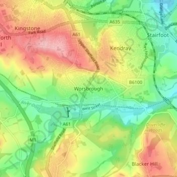
Nom : Carte topographique Worsbrough, altitude, relief.
Altitude moyenne : 98 m
Altitude minimum : 37 m
Altitude maximum : 172 m
Faire un don
Équipez-vous pour votre prochaine aventure :
En tant que Partenaire Amazon, ce site perçoit une commission sur les achats éligibles sans surcoût pour vous.
Autres cartes topographiques
Cliquez sur une carte pour visualiser sa topographie, son altitude et son relief.
Faire un don
Équipez-vous pour votre prochaine aventure :
En tant que Partenaire Amazon, ce site perçoit une commission sur les achats éligibles sans surcoût pour vous.
Shafton
United Kingdom > England > Barnsley
Shafton lies to the north of Shafton Two Gates, on the road to Ryhill. It is located at approximately 53° 35' 10" North, 1° 24' West, at an elevation of around 262 feet (80 m) above sea level. Sceptun in the Domesday Book of 1086 then later in c. 1160 Scaftona meaning a farmstead marked by a pole, or made…
Altitude moyenne : 65 m
High Hoyland
United Kingdom > England > Barnsley
High Hoyland is a village and civil parish in the Metropolitan Borough of Barnsley in South Yorkshire, England, on the border with West Yorkshire. It lies to the west of Kexbrough, and is located at approximately 53°35′10″N 1°35′30″W / 53.58611°N 1.59167°W / 53.58611; -1.59167, at an…
Altitude moyenne : 139 m
Faire un don
Équipez-vous pour votre prochaine aventure :
En tant que Partenaire Amazon, ce site perçoit une commission sur les achats éligibles sans surcoût pour vous.