
Carte topographique Carling Township
Carte interactive
Cliquez sur la carte pour afficher l’altitude.
À propos de cette carte
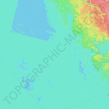
Nom : Carte topographique Carling Township, altitude, relief.
Altitude moyenne : 180 m
Altitude minimum : 172 m
Altitude maximum : 265 m
Autres cartes topographiques
Cliquez sur une carte pour visualiser sa topographie, son altitude et son relief.
The Archipelago Township
Canada > Ontario > Parry Sound District
The Archipelago Township, Parry Sound District, Central Ontario, Ontario, Canada
Altitude moyenne : 204 m
Shebeshekong Lake
Canada > Ontario > Parry Sound District > Carling Township
Shebeshekong Lake, Carling Township, Parry Sound District, Central Ontario, Ontario, Canada
Altitude moyenne : 205 m
South River
Canada > Ontario > Parry Sound District
South River, Parry Sound District, Central Ontario, Ontario, Canada
Altitude moyenne : 352 m
Jack's Ridge
Canada > Ontario > Parry Sound District > Unorganized Centre Parry Sound
Jack's Ridge, Unorganized Centre Parry Sound, Parry Sound District, Central Ontario, Ontario, Canada
Altitude moyenne : 254 m