
Carte topographique Megalopoli
Carte interactive
Cliquez sur la carte pour afficher l’altitude.
À propos de cette carte
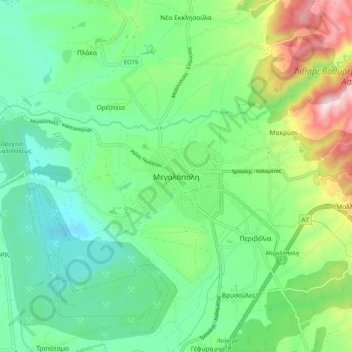
Nom : Carte topographique Megalopoli, altitude, relief.
Altitude moyenne : 434 m
Altitude minimum : 279 m
Altitude maximum : 811 m
Megalopoli is situated in a wide valley, surrounded by mountains: the Taygetus to the south, the Mainalo to the north, the Tsemperou to the southeast and the Lykaion to the west. Its elevation is 430 m above sea level. The river Alfeios flows through this valley, coming from the east and flowing to the north, passing south and west of the town. Its tributary Elissonas passes north of the town. The large lignite deposits around Megalopoli are being exploited by open-pit mining. The Megalopoli Power Plant, 3 km northwest of the town centre, has produced electricity from this lignite since 1969.
Autres cartes topographiques
Cliquez sur une carte pour visualiser sa topographie, son altitude et son relief.
Chirades
Greece > Peloponnese, Western Greece and the Ionian > Arcadia Regional Unit > Municipal Unit of Megalopoli
Chirades, Municipal Unit of Megalopoli, Municipality of Megalopoli, Arcadia Regional Unit, Peloponnese Region, Peloponnese, Western Greece and the Ionian, 222 00, Greece
Altitude moyenne : 708 m