
Carte topographique West Jordan
Carte interactive
Cliquez sur la carte pour afficher l’altitude.
À propos de cette carte
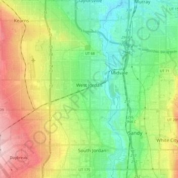
Nom : Carte topographique West Jordan, altitude, relief.
Lieu : West Jordan, Salt Lake County, Utah, United States (40.56594 -112.08259 40.64014 -111.91174)
Altitude moyenne : 1 372 m
Altitude minimum : 1 296 m
Altitude maximum : 1 507 m
West Jordan is a city in Salt Lake County, Utah, United States. It is a suburb of Salt Lake City. According to the 2020 Census, the city had a population of 116,961, placing it as the third most populous in the state. The city occupies the southwest end of the Salt Lake Valley at an elevation of 4,330 feet (1,320 m). Named after the nearby Jordan River, the limits of the city begin on the river's western bank and end in the eastern foothills of the Oquirrh Mountains, where Kennecott Copper Mine, the world's largest man-made excavation, is located.
Autres cartes topographiques
Cliquez sur une carte pour visualiser sa topographie, son altitude et son relief.
Torry Pines
United States > Utah > Salt Lake County > Sandy
Torry Pines, Sandy, Salt Lake County, Utah, 84070, United States
Altitude moyenne : 1 373 m
Sandy Heights South
United States > Utah > Salt Lake County > Sandy
Sandy Heights South, Sandy, Salt Lake County, Utah, 84070, United States
Altitude moyenne : 1 371 m
Salt Lake City
United States > Utah > Salt Lake County > Salt Lake City
Salt Lake City, Salt Lake County, Utah, 84139, United States
Altitude moyenne : 1 625 m
Salt Lake County
United States > Utah > Salt Lake County
Salt Lake County, Utah, United States
Altitude moyenne : 1 811 m