
Carte topographique Talavera
Carte interactive
Cliquez sur la carte pour afficher l’altitude.
À propos de cette carte
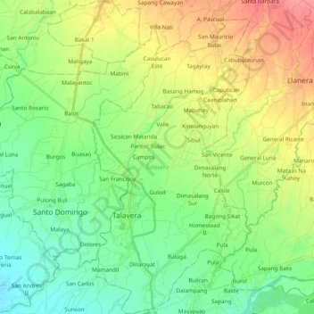
Nom : Carte topographique Talavera, altitude, relief.
Lieu : Talavera, Nueva Ecija, Central Luzon, 3114, Philippines (15.52730 120.87036 15.70895 120.99225)
Altitude moyenne : 49 m
Altitude minimum : 25 m
Altitude maximum : 88 m
Talavera is relatively flat, with a slope ranging from 0 to 3%. Its elevation, which ranges from 31m to 61m above sea level, with an average elevation of 42m, is importantly suitable for agricultural, commercial and industrial developments. Its aggregate arable land amounts to 12, 6981 ha or 89.075% of its total land area, of which less than 70% is irrigated or cultivated. Its land form consists generally of a broad expanse of low-lying level plains, with flattened terrains covered usually with greens or grasslands. The land profile is completely leveled, with relatively smooth-rolling surface and with little or no change at all in elevation.
Autres cartes topographiques
Cliquez sur une carte pour visualiser sa topographie, son altitude et son relief.
San Antonio
San Antonio, Nueva Ecija, Central Luzon, 3108, Philippines
Altitude moyenne : 15 m
Cabanatuan
Cabanatuan, Nueva Ecija, Central Luzon, 3100, Philippines
Altitude moyenne : 47 m