
Faire un don
Équipez-vous pour votre prochaine aventure :
En tant que Partenaire Amazon, ce site perçoit une commission sur les achats éligibles sans surcoût pour vous.
Carte topographique Palca
Cliquez sur la carte pour afficher l’altitude.
Faire un don
Équipez-vous pour votre prochaine aventure :
En tant que Partenaire Amazon, ce site perçoit une commission sur les achats éligibles sans surcoût pour vous.
À propos de cette carte
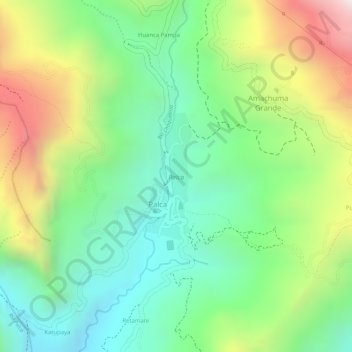
Nom : Carte topographique Palca, altitude, relief.
Lieu : Palca, Pedro Domingo Murillo, La Paz, Bolivia (-16.56388 -67.95484 -16.55408 -67.95026)
Altitude moyenne : 3 639 m
Altitude minimum : 3 367 m
Altitude maximum : 4 062 m
Faire un don
Équipez-vous pour votre prochaine aventure :
En tant que Partenaire Amazon, ce site perçoit une commission sur les achats éligibles sans surcoût pour vous.
Autres cartes topographiques
Cliquez sur une carte pour visualiser sa topographie, son altitude et son relief.
La Paz
Bolivia > La Paz > Pedro Domingo Murillo > La Paz
The city, in west-central Bolivia 68 km (42 mi) southeast of Lake Titicaca, is set in a canyon created by the Choqueyapu River. It is in a bowl-like depression, part of the Amazon basin, surrounded by the high mountains of the Altiplano. Overlooking the city is the towering, triple-peaked Illimani. Its peaks…
Altitude moyenne : 4 087 m
La Paz
Bolivia > La Paz > Pedro Domingo Murillo
The city, in west-central Bolivia 68 km (42 mi) southeast of Lake Titicaca, is set in a canyon created by the Choqueyapu River. It is in a bowl-like depression, part of the Amazon basin, surrounded by the high mountains of the Altiplano. Overlooking the city is the towering, triple-peaked Illimani. Its peaks…
Altitude moyenne : 3 544 m
Faire un don
Équipez-vous pour votre prochaine aventure :
En tant que Partenaire Amazon, ce site perçoit une commission sur les achats éligibles sans surcoût pour vous.
Mecapaca
Bolivia > La Paz > Pedro Domingo Murillo
Mecapaca Municipality is the second municipal section of the Pedro Domingo Murillo Province in the La Paz Department, Bolivia. Its seat is Mecapaca. It is situated 28 km from the city of La Paz, the capital of the department and the seat of government for the country, and it stands at an elevation of 2,850…
Altitude moyenne : 3 684 m
Illimani
Bolivia > La Paz > Pedro Domingo Murillo > Palca
Illimani (Aymara and Spanish pronunciation: [iʎiˈmani]) is a prominent fold mountain within the Cordillera Real of Bolivia, a subrange of the greater Andes, and located approximately 82 kilometres (51 mi) southeast of La Paz. With an elevation of 6,438 metres (21,120 ft) at its summit, it is the highest…
Altitude moyenne : 5 756 m
Faire un don
Équipez-vous pour votre prochaine aventure :
En tant que Partenaire Amazon, ce site perçoit une commission sur les achats éligibles sans surcoût pour vous.
La Paz
Bolivia > La Paz > Pedro Domingo Murillo
Located in west-central Bolivia 68 km (42 mi) southeast of Lake Titicaca, La Paz is set in a canyon created by the Choqueyapu River. It is in a bowl-like depression, part of the Amazon basin, surrounded by the high mountains of the Altiplano. Overlooking the city is the triple-peaked Illimani. Its peaks are…
Altitude moyenne : 3 544 m
Faire un don
Équipez-vous pour votre prochaine aventure :
En tant que Partenaire Amazon, ce site perçoit une commission sur les achats éligibles sans surcoût pour vous.
Faire un don
Équipez-vous pour votre prochaine aventure :
En tant que Partenaire Amazon, ce site perçoit une commission sur les achats éligibles sans surcoût pour vous.
Faire un don
Équipez-vous pour votre prochaine aventure :
En tant que Partenaire Amazon, ce site perçoit une commission sur les achats éligibles sans surcoût pour vous.
La Paz
Bolivia > La Paz > Pedro Domingo Murillo
The city, in west-central Bolivia 68 km (42 mi) southeast of Lake Titicaca, is set in a canyon created by the Choqueyapu River. It is in a bowl-like depression, part of the Amazon basin, surrounded by the high mountains of the Altiplano. Overlooking the city is the triple-peaked Illimani. Its peaks are always…
Altitude moyenne : 3 544 m
Faire un don
Équipez-vous pour votre prochaine aventure :
En tant que Partenaire Amazon, ce site perçoit une commission sur les achats éligibles sans surcoût pour vous.
Faire un don
Équipez-vous pour votre prochaine aventure :
En tant que Partenaire Amazon, ce site perçoit une commission sur les achats éligibles sans surcoût pour vous.
La Paz
Bolivia > La Paz > Pedro Domingo Murillo
Located in west-central Bolivia 68 km (42 mi) southeast of Lake Titicaca, La Paz is set in a canyon created by the Choqueyapu River. It is in a bowl-like depression, part of the Amazon basin, surrounded by the high mountains of the Altiplano. Overlooking the city is the triple-peaked Illimani. Its peaks are…
Altitude moyenne : 3 544 m
Faire un don
Équipez-vous pour votre prochaine aventure :
En tant que Partenaire Amazon, ce site perçoit une commission sur les achats éligibles sans surcoût pour vous.