
Carte topographique Qinghai
Carte interactive
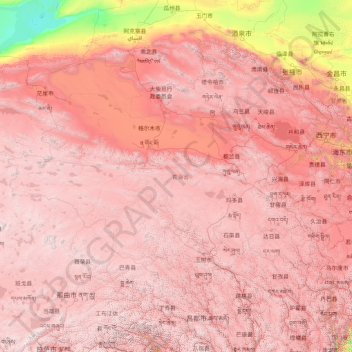
Cliquez sur la carte pour afficher l’altitude.
À propos de cette carte
Nom : Carte topographique Qinghai, altitude, relief.
Lieu : Qinghai, China (31.60180 89.40222 39.21423 103.06941)
Altitude moyenne : 3 710 m
Altitude minimum : 787 m
Altitude maximum : 6 545 m
The average elevation of Qinghai is over 3,000 metres (9,800 ft) above sea level. Mountain ranges include the Tanggula Mountains and Kunlun Mountains, with the highest point being Bukadaban Feng at 6,860 metres (22,510 ft). Due to the high altitude, Qinghai has quite cold winters (harsh in the highest elevations), mild summers, and a large diurnal temperature variation. Its mean annual temperature is approximately −5 to 8 °C (23 to 46 °F), with January temperatures ranging from −18 to −7 °C (0 to 19 °F) and July temperatures ranging from 15 to 21 °C (59 to 70 °F). It is also prone to heavy winds as well as sandstorms from February to April. Significant rainfall occurs mainly in summer, while precipitation is very low in winter and spring, and is generally low enough to keep much of the province semi-arid or arid.