
Carte topographique East Lansing
Carte interactive
Cliquez sur la carte pour afficher l’altitude.
À propos de cette carte
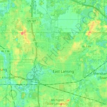
Nom : Carte topographique East Lansing, altitude, relief.
Lieu : East Lansing, Ingham County, Michigan, United States (42.69726 -84.51351 42.80098 -84.43887)
Altitude moyenne : 261 m
Altitude minimum : 247 m
Altitude maximum : 289 m
Autres cartes topographiques
Cliquez sur une carte pour visualiser sa topographie, son altitude et son relief.
Lansing
United States > Michigan > Ingham County
Lansing, Ingham County, Michigan, United States
Altitude moyenne : 263 m
Williamston
United States > Michigan > Ingham County
Williamston, Ingham County, Michigan, 48895, United States
Altitude moyenne : 268 m
Lansing Charter Township
United States > Michigan > Ingham County
Lansing Charter Township, Ingham County, Michigan, United States
Altitude moyenne : 262 m
North Aurelius
United States > Michigan > Ingham County > North Aurelius
North Aurelius, Aurelius Township, Ingham County, Michigan, United States
Altitude moyenne : 277 m
Mason
United States > Michigan > Ingham County > Mason
Mason, Ingham County, Michigan, 48854, United States
Altitude moyenne : 276 m
Okemos
United States > Michigan > Ingham County > Okemos
Okemos, Meridian Charter Township, Ingham County, Michigan, United States
Altitude moyenne : 264 m