
Carte topographique Gençlik Parkı
Carte interactive
Cliquez sur la carte pour afficher l’altitude.
À propos de cette carte
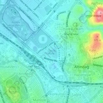
Nom : Carte topographique Gençlik Parkı, altitude, relief.
Altitude moyenne : 870 m
Altitude minimum : 842 m
Altitude maximum : 1 000 m
The 27.5 ha (68 acres) park is almost at the center of Ankara. Its altitude is about 850 m (2,790 ft), which makes it one of the lowest points in Ankara. It is surrounded by Ulus Square to the north, the Ankara Opera House (formerly Ankara Exhibition Building) to the east, Selim Sırrı Tarcan Sport Hall and Ankara Central Station to the south and, 19 Mayıs Stadium to the west.
Autres cartes topographiques
Cliquez sur une carte pour visualiser sa topographie, son altitude et son relief.