
Carte topographique Bulisa
Carte interactive
Cliquez sur la carte pour afficher l’altitude.
À propos de cette carte
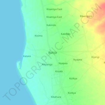
Nom : Carte topographique Bulisa, altitude, relief.
Lieu : Bulisa, Buliisa, Western Region, Uganda (2.07803 31.37152 2.15803 31.45152)
Altitude moyenne : 629 m
Altitude minimum : 615 m
Altitude maximum : 664 m
Buliisa is located in the northwestern corner of Buliisa District, along the shores of Lake Albert, approximately 91 kilometres (57 mi), by road, north of Hoima, the largest city in the Bunyoro sub-region. This is approximately 299 kilometres (186 mi), by road, northwest of Kampala, Uganda's capital and largest city. The geographical coordinates of Buliisa Town are:02°07'18.0"N, 31°24'56.0"E (Latitude:2.121667; Longitude:31.415556). The town sits at an average elevation of 627 metres (2,057 ft) above mean sea level.
Autres cartes topographiques
Cliquez sur une carte pour visualiser sa topographie, son altitude et son relief.