
Carte topographique Millstone Township
Carte interactive
Cliquez sur la carte pour afficher l’altitude.
À propos de cette carte
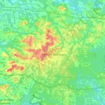
Nom : Carte topographique Millstone Township, altitude, relief.
Altitude moyenne : 49 m
Altitude minimum : 24 m
Altitude maximum : 104 m
Autres cartes topographiques
Cliquez sur une carte pour visualiser sa topographie, son altitude et son relief.
Perrineville
United States of America > New Jersey > Millstone Township > Perrineville
Perrineville, Millstone Township, Monmouth County, New Jersey, 08535, United States of America
Altitude moyenne : 62 m