
Carte topographique Mae Hong Son Province
Carte interactive
Cliquez sur la carte pour afficher l’altitude.
À propos de cette carte
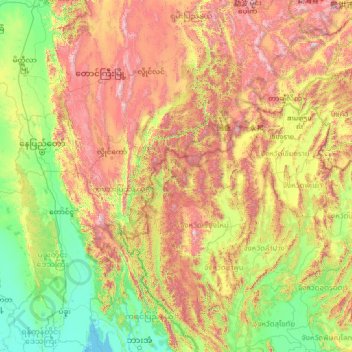
Nom : Carte topographique Mae Hong Son Province, altitude, relief.
Lieu : Mae Hong Son Province, Thailand (16.83275 95.64311 21.95275 100.76311)
Altitude moyenne : 604 m
Altitude minimum : -1 m
Altitude maximum : 2 516 m
The Daen Lao Range, in the northernmost portion of the province, marks the northern boundary between Thailand and Burma, while the Dawna Range in the west serves as the boundary between Thailand and Burma. The Thanon Thongchai Range in the east of the province serves as the boundary between the provinces of Mae Hong Son and Chiang Mai. The highest point of the province is Doi Mae Ya (ยอดเขาแม่ยะ), in the Pai District in the province's northeast, at 2,005 metres (6,578 ft) elevation.
Autres cartes topographiques
Cliquez sur une carte pour visualiser sa topographie, son altitude et son relief.
Ban Ja Bo
Thailand > Mae Hong Son Province > Ban Jabo
Ban Ja Bo, 1226, Ban Jabo, Pang Mapha, Mae Hong Son Province, Thailand
Altitude moyenne : 886 m
Mae U Mong Luang
Thailand > Mae Hong Son Province > Soppong
Mae U Mong Luang, Soppong, Pang Mapha, Mae Hong Son Province, Thailand
Altitude moyenne : 775 m
Pai
Thailand > Mae Hong Son Province
Pai, Mae Hong Son Province, 58130, Thailand
Altitude moyenne : 605 m