
Carte topographique Hills
Carte interactive
Cliquez sur la carte pour afficher l’altitude.
À propos de cette carte
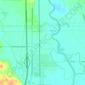
Nom : Carte topographique Hills, altitude, relief.
Lieu : Hills, Johnson County, Iowa, 52235, United States (41.54368 -91.54509 41.58380 -91.52260)
Altitude moyenne : 196 m
Altitude minimum : 186 m
Altitude maximum : 229 m
Autres cartes topographiques
Cliquez sur une carte pour visualiser sa topographie, son altitude et son relief.
Tiffin
United States > Iowa > Johnson County
Tiffin, Johnson County, Iowa, 52340, United States
Altitude moyenne : 227 m
Coralville
United States > Iowa > Johnson County
Coralville, Johnson County, Iowa, 52241, United States
Altitude moyenne : 224 m
North Liberty
United States > Iowa > Johnson County
North Liberty, Johnson County, Iowa, 52317, United States
Altitude moyenne : 235 m
Iowa City
United States > Iowa > Johnson County > Iowa City
Iowa City, Johnson County, Iowa, 52240-5544, United States
Altitude moyenne : 225 m
Iowa City
United States > Iowa > Johnson County
Iowa City, Johnson County, Iowa, United States
Altitude moyenne : 216 m