
Carte topographique Kasendorf
Carte interactive
Cliquez sur la carte pour afficher l’altitude.
À propos de cette carte
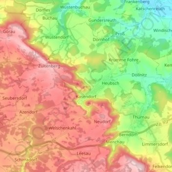
Nom : Carte topographique Kasendorf, altitude, relief.
Altitude moyenne : 425 m
Altitude minimum : 292 m
Altitude maximum : 560 m
Autres cartes topographiques
Cliquez sur une carte pour visualiser sa topographie, son altitude et son relief.
Thurnau
Deutschland > Bayern > Landkreis Kulmbach
Thurnau, Landkreis Kulmbach, Bayern, 95349, Deutschland
Altitude moyenne : 433 m
Marktleugast
Deutschland > Bayern > Landkreis Kulmbach
Marktleugast, Marktleugast (VGem), Landkreis Kulmbach, Bayern, Deutschland
Altitude moyenne : 561 m