
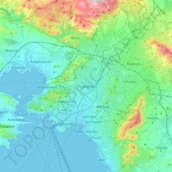
Carte topographique Peristeri
Carte interactive
Cliquez sur la carte pour afficher l’altitude.
À propos de cette carte
Nom : Carte topographique Peristeri, altitude, relief.
Altitude moyenne : 223 m
Altitude minimum : -3 m
Altitude maximum : 1 365 m
Autres cartes topographiques
Cliquez sur une carte pour visualiser sa topographie, son altitude et son relief.
Municipal Unit of Kamatero
Greece > Attica > Regional Unit of West Athens
Municipal Unit of Kamatero, Municipality of Agioi Anargyroi-Kamatero, Regional Unit of West Athens, Attica, 134 51, Greece
Altitude moyenne : 153 m
Municipality of Aigaleo
Greece > Attica > Regional Unit of West Athens
Municipality of Aigaleo, Regional Unit of West Athens, Attica, Greece
Altitude moyenne : 46 m
Municipality of Petroupoli
Greece > Attica > Regional Unit of West Athens
Municipality of Petroupoli, Regional Unit of West Athens, Attica, 132 31, Greece
Altitude moyenne : 222 m
Municipality of Peristeri
Greece > Attica > Regional Unit of West Athens
Municipality of Peristeri, Regional Unit of West Athens, Attica, Greece
Altitude moyenne : 80 m