
Carte topographique Chehalis
Carte interactive
Cliquez sur la carte pour afficher l’altitude.
À propos de cette carte
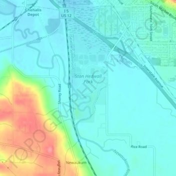
Nom : Carte topographique Chehalis, altitude, relief.
Altitude moyenne : 67 m
Altitude minimum : 48 m
Altitude maximum : 131 m
Autres cartes topographiques
Cliquez sur une carte pour visualiser sa topographie, son altitude et son relief.
Lewis County
United States > Washington > Lewis County
Lewis County, Washington, United States
Altitude moyenne : 558 m
Chehalis
United States > Washington > Lewis County > Chehalis > Chehalis
Chehalis, Lewis County, Washington, United States
Altitude moyenne : 85 m
Randle
United States > Washington > Lewis County > Randle
Randle, Lewis County, Washington, United States
Altitude moyenne : 378 m