
Carte topographique Estes Park
Carte interactive
Cliquez sur la carte pour afficher l’altitude.
À propos de cette carte
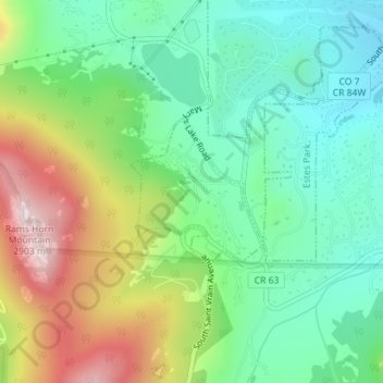
Nom : Carte topographique Estes Park, altitude, relief.
Lieu : Estes Park, Larimer County, Colorado, United States (40.33115 -105.53675 40.34158 -105.52449)
Altitude moyenne : 2 543 m
Altitude minimum : 2 354 m
Altitude maximum : 2 897 m
Estes Park sits at an elevation of 7,522 feet (2,293 m) on the front range of the Rocky Mountains at the eastern entrance of the Rocky Mountain National Park. Its location is 40°22′22″N 105°31′09″W / 40.372856°N 105.519136°W / 40.372856; -105.519136. Its north, south and east extremities border the Roosevelt National Forest. Lumpy Ridge lies immediately north of Estes Park.
Autres cartes topographiques
Cliquez sur une carte pour visualiser sa topographie, son altitude et son relief.
Stanley Heights Subdivision
United States > Colorado > Larimer County > Estes Park
Stanley Heights Subdivision, Estes Park, Larimer County, Colorado, 80517, United States
Altitude moyenne : 2 345 m