
Carte topographique Chiribiquete (Macizo Central)
Carte interactive
Cliquez sur la carte pour afficher l’altitude.
Chiribiquete (Macizo Central)
Chiribiquete National Park is situated in the western region of the Guiana Shield, east of the Eastern Cordillera, north of the Amazonian plains, west of the Upper Río Negro, and south of the savannas of the Orinoquía. Elevations in the park range from about 200 to 1,000 metres above sea level. It contains geological formations that are made up of plateaus and steep rocky structures. The formations are divided into three different sections: the Northern Massif, the Central Massif and Iguaje Messas. The park is well known for its tepuis, table-top mountains that abruptly rise from the forest. The mountain ridge of Chiribiquete is an important remnant of the rocky chain belonging to the Precambrian and Paleozoic formations that make up the Guiana Shield.
À propos de cette carte
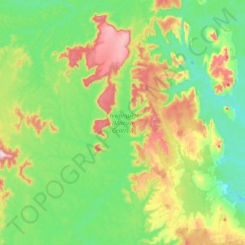
Nom : Carte topographique Chiribiquete (Macizo Central), altitude, relief.
Lieu : Chiribiquete (Macizo Central), Solano, Caquetá, Colombia (0.38732 -72.96391 0.79344 -72.67372)
Altitude moyenne : 290 m
Altitude minimum : 154 m
Altitude maximum : 588 m
Autres cartes topographiques
Cliquez sur une carte pour visualiser sa topographie, son altitude et son relief.