
Carte topographique Eagle's Crag
Carte interactive
Cliquez sur la carte pour afficher l’altitude.
À propos de cette carte
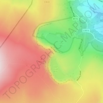
Nom : Carte topographique Eagle's Crag, altitude, relief.
Altitude moyenne : 490 m
Altitude minimum : 244 m
Altitude maximum : 693 m
Autres cartes topographiques
Cliquez sur une carte pour visualiser sa topographie, son altitude et son relief.
Lower Lough Bray
Lower Lough Bray, Powerscourt ED, The Municipal District of Bray, County Wicklow, Leinster, Irland
Altitude moyenne : 455 m
The Municipal District of Wicklow
The Municipal District of Wicklow, County Wicklow, Leinster, Irland
Altitude moyenne : 263 m