
Carte topographique Uppsala
Carte interactive
Cliquez sur la carte pour afficher l’altitude.
À propos de cette carte
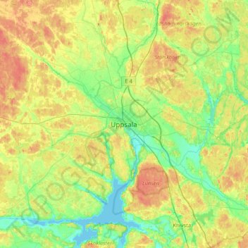
Nom : Carte topographique Uppsala, altitude, relief.
Lieu : Uppsala, Uppsala kommun, Uppsala County, 753 20, Sweden (59.69861 17.47874 60.01861 17.79874)
Altitude moyenne : 29 m
Altitude minimum : -4 m
Altitude maximum : 81 m
Situated on the fertile Uppsala flatlands of muddy soil, the city features the small Fyris River (Fyrisån) flowing through the landscape surrounded by lush vegetation. Parallel to the river runs the glacial ridge of Uppsalaåsen at an elevation around 30 m (98 ft), the site of Uppsala's castle, from which large parts of the town can be seen. The central park Stadsskogen (literally "City Forest") stretches from the south far into town, with opportunities for recreation for many residential areas within walking distance.
Autres cartes topographiques
Cliquez sur une carte pour visualiser sa topographie, son altitude et son relief.
Älvkarleby kommun
Älvkarleby kommun, Uppsala County, Sweden
Altitude moyenne : 20 m
Älvkarleby kommun
Älvkarleby kommun, Uppsala County, Sweden
Altitude moyenne : 22 m